Looking south across Chatham Sound from Kitson Island with my kayak ready to launch at the waters edge.
 Today’s paddle into Prince Rupert would only be 12 miles in protected waters, and since it was drizzling outside, I took the opportunity to sleep a little later than normal. After eating breakfast and getting everything packed up while under the pyramid shelter, I launched from my Kitson Island campsite at 9am. The tide was very low, and I had to carry the boat and gear a long way to the waters edge, but at least the beach was packed sand and not slippery rocks.
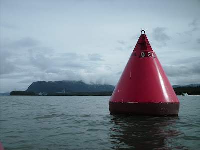
A buoy marks the channel into Prince Rupert.
I started heading east around Kitson Island and ran into water so shallow that even my kayak was bottoming out. After changing course to the west, I found a deeper channel out into Chatham Sound and made my way north to Prince Rupert. The waterway leading into Prince Rupert harbor is lined with industrial facilities for loading shipping containers, grain, and coal. Railroad tracks follow the shoreline closely the whole way into town.

Approaching the bulk loading dock in Prince Rupert.
As soon as I reached the main docks in town at 12 noon, I spotted a small floating dock with a rack full of kayaks on it. I pulled up and inquired as to the possibility of storing my kayak here for a couple of nights while I was in town. I was directed to contact Joe at the phone number that appeared on a sign on the kayak rack. Since cell phones do not work in Prince Rupert, I had to get to a pay phone. I tied up the kayak, got into some dry clothes, and set off to find lodging and call Joe. My pre-trip research had provided me with a list of available lodging options and a street map of Prince Rupert. I made my way to the Pioneer Hostel and got a room for the next two nights. Now that I knew where I was going to be staying, I called Joe to get permission to store my boat on his dock. I reached Joe Paolinelli the owner of Skeena Kayaking and he kindly gave me the authorization I was seeking. We made plans to meet for dinner the next night and I was set to go. After retrieving a few things from my kayak and putting it on the rack where Joe had instructed me, I headed back to the hostel, took a shower, and set off to get something to eat and explore the town.

The container dock in Prince Rupert.
The map I used to find my way around Prince Rupert and locate lodging was one of the most useful things I had on my trip. It is published by Great Pacific Recreation & Travel Maps and is titled “SE Alaska’s Inside Passage recreation finder map and guide“. Besides having a very detailed overview of the Alaska section of the Inside Passage, it also has a smaller view of the Canadian section. On the opposite side are detailed maps of every town along the route with the name, phone number and map location of lodging, attractions, marinas, hospitals, post offices and dozens of other facilities that could come in handy for a kayaker passing through. I was using the second edition of this map and unfortunately, some of the B&B’s that it has listed have closed so you might want to call to verify what facilities are available before leaving home.
I also want to note that although Joe at Skeena Kayaking was nice enough to let me use his facility he and other kayaking business owners should not be expected to do this for every paddler passing through. A more reliable alternative I found was to paddle up to the harbormasters office and get a place assigned for your boat for however long you plan to be in port. I did this in Shearwater, Petersburg, and Juneau and it worked just fine. In every case, I was assigned a location right next to the gangway that was both safe and convenient.